The Indian truth behind the ruins of Takshasila


 |
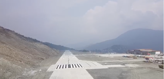
| Approach at Pakyong airport |
Gangtok is the capital of Sikkim which is the home to glaciers, alpine meadows and thousands of varieties of wildflowers. Steep paths lead to hilltop Buddhist monasteries such as Pemayangtse, which dates to the early 1700s. Access to Gangtok has always been by road which takes five hours to reach from the nearest airport, which is Baghdogra. Sikkim is also of strategic importance due to its location. The construction of an airport at Pakyong near Gangtok would therefore would hold much importance and with the inauguration of the airport by the Prime Minister in Sept 2018, marked the culmination of the Sikkim dream of air connectivity.
However, this dream was short lived since the airport could not be used for 18 months due to operational reasons. The airport is a table top runway set amidst high hills. The airport is at a height of 4600ft and a hill on one side and steep drop on the other side. The construction of the airport was an engineering challenge since the slopes had to be flattened without disturbing the earth stability and flow of water through the natural channels. The project cost was approx INR 605 Cr.
The airport was initially a Visual Flight Rules airport since there was no instrument approach procedure designed which would aid the pilots to descend in less than 5km visibility. The width of the runway is 30m wide and is suitable for an aircraft like the ATR which has a narrow wheel base having the wheels directly under the belly of the aircraft. The same goes for the taxiway when the aircraft vacates the runway to reach the terminal building.
Visibility in the hills is not always the best to meet with the requirements of the airport where the hills are too close to the runway that the pilots must at all times have the hills in sight and visually avoid them. Since the visibility wasn't favorable, the airport couldn't be used for 18 months till an aircraft based approach was designed.
Runway safety area is defined as "the surface surrounding the runway prepared or suitable for reducing the risk of damage to airplanes in the event of an excursion from the runway. The International Conventions and the Indian regulator mandates that this safety area shall be 140m wide however, Pakyong runway has only 80m of safety area. This means that in the eventuality of an aircraft going off the sides of the runway, there is inadequate protection.
The width of the runway is 30m whereas the aircraft currently flown in and out of the airport is a SpiceJet Dash8-Q400. The international conventions and the Indian regulator mandates that the aircraft of such dimensions that of a Q400 requires a runway 45m wide. This would mean that in the eventuality of an engine failure on takeoff, the aircraft might go off the runway. The wheels of the Q400 are placed under the engines which are farther apart than say an ATR which have the wheels under the belly.
The width of the wheel base of a Q400 is more than an Airbus A320. The aerodrome design manual issued by the aircraft manufacturer states that the runway width required for the Dash8-Q400 is 45m. The European regulator has refused permission to the manufacturer to allow operation of flight at airport with width less than 45m since the figure has been the outcome of detailed research by international bodies and safety could not be compromised with.

European regulator denying Dash8 manufacturer to operate with reduced requirements
The width of the taxiway is 18m whereas the Spicejet Q400 aircraft requires 23m as per International conventions and the Indian regulator. The operator simply cautions the pilots to be careful while taxying to avoid going off the taxiway.
The aircraft based instrument procedure is designed for CAT A/B aircrafts. This category is allocated as per the approach speed of the aircraft. The SpiceJet Q400 aircraft flown is categorized as CAT C as per all other regulators but for reasons unknown the Indian regulator has designated the Q400 under CAT B. This means that the aircraft might not adhere with the instrument approach requirements.

FAA(USA REGULATOR) CATEGORISATION
The visibility requirement as per the Indian regulations for an approach at Pakyong with high hills in the vicinity is 4100m whereas the Indian regulator has approved SpiceJet to operate the Q400 even when the visibility is poorer than 4100m down to an astonishing 2400m. The regulations do not permit the aircraft to land unless the visibility at the airport is 4100m or greater so that the pilots can see the runway and the hills around from a distance. The lower than regulations minimum risk the pilots closer to the hills making it highly unsafe.
Comments
Post a Comment